The short answer? Apparently they are required to withstand magnitudes that are unlikely to happen more than once every ten-thousand years (Dam safety and earthquakes).
An overview that describes a bit about dams and mentions a couple of intense scenarios:
A large storage dam consists of a concrete or fill dam with a height exceeding 15m, a grout curtain or cut-off to minimise leakage of water through the dam foundation, a spillway for the safe release of floods, a bottom outlet for lowering the reservoir in emergencies, and a water intake structure to take the water from the reservoir for commercial use. Depending on the use of the reservoir there are other components such as a power intake, penstock, powerhouse, device for control of environmental flow, fish ladder, etc.
During the Richter magnitude 8 Wenchuan earthquake of 12 May 2008, 1803 concrete and embankment dams and reservoirs and 403 hydropower plants were damaged. Likewise, during the 27 February 2010 Maule earthquake in Chile of Richter magnitude 8.8, several dams were damaged. However, no large dams failed due to either of these two very large earthquakes.
What earthquake action does a dam have to withstand?
In order to prevent the uncontrolled rapid release of water from the reservoir of a storage dam during a strong earthquake, the dam must be able to withstand the strong ground shaking from even an extreme earthquake, which is referred to as the Safety Evaluation Earthquake (SEE) or the Maximum Credible Earthquake (MCE). Large storage dams are generally considered safe if they can survive an event with a return period of 10,000 years, i.e. having a one percent chance of being exceeded in 100 years. It is very difficult to predict what can happen during such a rare event as very few earthquakes of this size have actually affected dams. Therefore it is important to refer to the few such observations that are available. The main lessons learnt from the large Wenchuan and Chile earthquakes will have an impact on the seismic safety assessment of existing dams and the design of new dams in the future.
There are some interesting, more-technical comments here about the science of measurement:
Buried deep within this pdf of a powerpoint presentation on the Hoover Dam are a few statements about the dam design with respect to ground motion from earthquakes. It was designed to withstand horizontal ground acceleration up to 0.1g.
Correlating peak ground acceleration to a scale of earthquake intensity, like the Mercalli scale, is reasonably straight forward and the maximum ground acceleration for the Hoover Dam of 0.1g corresponds to a Mercalli intensity of VI, with strong shaking but light damage.
Now, correlating ground acceleration or an intensity of shaking at a point with an earthquake magnitude (the correct term is the moment magnitude scale, the richter scale has not been used since the 1930’s) is not straight forward as it depends on a lot of factors. As mentioned in the article you linked to, seismic waves attenuate as they travel, so the ground acceleration at a location will depend on the distance from that location to the earthquake hypocenter (actual point on fault of failure) and epicenter (projection of hypocenter location to surface of earth). A bigger factor is actually the material in the location of interest. “Stiffer” material, like intact igneous or metamorphic bedrock will transfer seismic waves more efficiently, allowing for further propagation of strong shaking (distance wise). Seismic waves will attenuate quicker in less consolidated material (sediment) or very fractured rocks, but especially in unconsolidated sediment, seismic waves will often reverberate and can actually increase the peak ground acceleration through constructive interference. If you look at that page on peak ground acceleration and scroll down to the bottom, you can see just how variable this can be, for example the magnitude 6.0 2011 Christchurch earthquake had a PGA of 1.0g whereas the 1964 Great Alaska earthquake that was 9.2 magnitude had a PGA of 0.18g, despite those differences in magnitude being equivalent to the Alaska earthquake releasing ~63,000 times more energy than the New Zealand 6.0. This difference in PGA can be attributed to different depths for the hypocenters and very different materials through which the seismic waves traveled.
This is ultimately why developing detailed seismic hazard maps required lots of geological data, not just locations of faults, but the histories of earthquakes on those faults and the geology of the region in question.Take a look at this seismic hazard map from the USGS of Nevada. This is presented in terms of a 2% chance in the next 50 years of a given region experiencing a particular peak ground acceleration. The color code is the PGA in percent of 1g, so the Hoover Dam was engineered for a 10 on this scale, and you can see that the location of the dam is in the 14-20, meaning that there is a 2% chance in the next 50 years of an earthquake happening that could cause PGA above the engineering tolerances of the Hoover Dam. Whether this would actually cause failure of the dam is a question for an engineer.
TL;DR – To directly answer your question, yes, there have been many many earthquake that have occurred that could destroy the Hoover Dam, mainly because the Hoover Dam was not engineered to withstand ground acceleration over 0.1g, but Tom Rockwell was right in that article you linked, an earthquake on the San Andreas is not going to cause this because of the distances involved. This more generally accentuates the importance of understanding the seismic hazard of a particular area when building critical structures, i.e. the peak ground acceleration you need to plan for depends entirely on where you are building.
(Approximately what magnitude earthquake would it require to destroy the Hoover Dam?)
I found these numbers pretty intense and the significant variation of the actual forces due to terrain/earth composition very interesting:
If you look at that page on peak ground acceleration and scroll down to the bottom, you can see just how variable this can be, for example the magnitude 6.0 2011 Christchurch earthquake had a PGA of 1.0g whereas the 1964 Great Alaska earthquake that was 9.2 magnitude had a PGA of 0.18g, despite those differences in magnitude being equivalent to the Alaska earthquake releasing ~63,000 times more energy than the New Zealand 6.0. This difference in PGA can be attributed to different depths for the hypocenters and very different materials through which the seismic waves traveled.
This is ultimately why developing detailed seismic hazard maps required lots of geological data, not just locations of faults, but the histories of earthquakes on those faults and the geology of the region in question.
A hypocenter is where the earthquake originates, described in three-dimensions.
Featured Image
The featured image is what you get when you turn a surface the size of nine football fields into a movie screen: FREIGHTLINER BREAKS RECORD WITH HOOVER DAM PROJECTION MAPPING
Here is another cool picture I found of the dam being built:
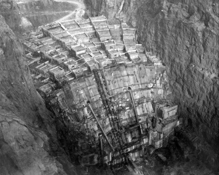
(Hoover Dam – Building the Dam)
The dam was built by pouring concrete, one interlocking-block at a time: small ones were 25′ x 25′, large ones were 25′ x 60′, and both were 5′ high.
It is a colossal structure. Want a way to measure how colossal without actually seeing it? Over two-hundred men died while building it due to falling or industrial accidents (none died in the concrete, though).
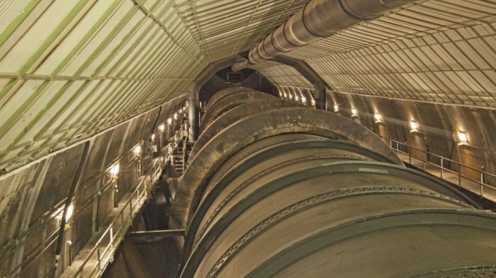
Here is a picture of some internally plumbing (because engineers love plumbing):